The eight climographs below show yearly temperature (line graph and left vertical axis) and precipitation (bar graph and right vertical axis) averages for each month for some locations on Earth. Choose the climograph that best answers the question or completes the statement. Climographs may be used once, more than once, or not at all.
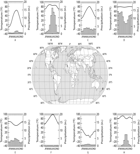
-Which of the following best substantiates why location 3 is an equatorial (tropical) climate?
Definitions:
Precipitation
Any type of water, be it in liquid or solid state, which descends from the sky and lands on the Earth's surface, such as rain, snow, sleet, and hail.
Large Grazers
Large herbivorous animals that feed primarily on grass and other low-lying vegetation.
Semiarid Zones
Regions characterized by light rainfall, usually between 10 and 20 inches per year, often resulting in scanty vegetation and a steppe climate.
Q7: Making derogatory comments implying sexual unattractiveness can
Q24: Short-term memory information processing usually causes changes
Q32: Why do moderate levels of disturbance result
Q35: What would be the effect on climate
Q56: Secondary consumers that can eat only primary
Q62: If you were the HR advisor of
Q69: The blind spot in the human retina
Q70: Neurotransmitters affect postsynaptic cells by<br>A) initiating signal
Q73: Lateral inhibition via amacrine cells in the
Q76: Which of the following is an adult