Figure 7.4 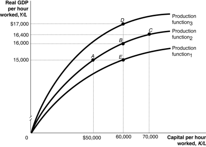 Alt text for Figure 7.4: In figure 7.4, a graph representing per-worker production functions.
Long description for Figure 7.4: The x-axis is labelled, capital per hour worked, K/L.The y-axis is labelled, real GDP per hour worked, Y/L.3 concave curves originating from 0 at the vertex are shown.5 points A ($50000, $15000) , B ($60000, $16000) , C ($70000, $16400) , D ($60000, $17000) , and E ($60000, $15000) are plotted.The curve labelled, Production function 1, passes through point E.The curve labelled, Production function 2, passes through points A, B, and C.The curve labelled, Production function 3, passes through point D.These 5 points are connected to their respective coordinates on the x-axis and y-axis with dotted lines.
-Refer to Figure 7.4.Which of the following combinations of points illustrates changes in the Soviet Union's economy from 1950 to 1980?
Definitions:
Longshore Current
A current, generally in an ocean or large lake, flowing more or less parallel to a coastline.
Prevailing Wind
The most common or frequent wind direction in a particular place, influenced by global patterns or local topography.
Shoreline Sand
Sand found along the edge of a sea, lake, or river, commonly composed of finely divided rocks and mineral particles.
Low Tide
The state of the tide when it is at its lowest level, resulting in the minimal reach of seawater on the shore.
Q12: Canadian National Railways (CN)plays such a large
Q12: Which of the following will increase investment
Q18: If the marginal propensity to save is
Q28: Which of the following financial securities is
Q70: The consumption function describes the relationship between<br>A)consumption
Q117: If real GDP per capita in Canada
Q157: Increases in real GDP since 1961 can
Q198: In Canada, since the 1970s, expansions are
Q230: The cost to firms of changing prices<br>A)is
Q250: If the growth rate of real GDP