Multiple Choice
This map shows contours of the water table,the location of four factories (labeled A,B,C,and D) ,and contaminated and uncontaminated wells.Which way will the contamination flow? 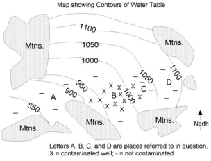
Definitions:
Related Questions
Q15: On this map of South America and
Q25: What is NOT true about how terraces
Q37: Some coal mines are called strip mines
Q45: All of the following except _ can
Q55: The sand dunes shown in this photograph:
Q56: This figure shows how sunlight strikes the
Q68: For these ocean currents in the Atlantic,which
Q78: What events occurred in 2004,as described by
Q85: Regional elevation can be increased by:<br>A)thrust faulting
Q98: Which of the following is a valid